
Detection of River Flow Velocity and Flow by UHF Radar
Radar band: UHF band < br > 2. Power supply voltage: 220 VAC or 24 VDC < br> 3. Average power: 90
I. Technical Requirements
(1) UHF Radar (High Precision Measurement of Vector Flow Field) 1/set
Technical parameters of product specifications:
Radar band: UHF band
2. Power supply voltage: 220 VAC or 24 VDC
3. Average power: 90 W
4. Working Temperature: -25 ~65.
5. Data transmission mode: 3. 4G network, wired network, WIFI
6. Radar Local Storage Size: 2T
7. Local maximum storage time: 2 years (preservation of original echo data)
8. Flow measurement interval: user-configurable (default hour)
9. Coverage area: 400 m x 400 m
10. Measuring River Width: > 100m
11. Azimuth Resolution: 1 degree
12. Distance resolution: 10 m to 30 m
_13. Mesh resolution of vector flow field: 10 *10 M
14. Measurement range of velocity: not less than 2.0 cm/s-500 cm/s
15. Surface velocity resolution: 2.0 cm/s
16. Coefficient of correlation for surface velocity measurement: 0.98
17. Flow measurement error:<5%
18. Working time of solar energy theory in rainy weather: no less than 40 days
19. Low-light solar panel power: 900 W
20. Lead-acid batteries: 24 V, 250 Ah
(2) Computer Terminal Servers: 2
(3) Technical parameters of software product specifications:
Untitled - 1
1. The software system includes system setup, system testing, data acquisition and data communication, while the application software includes data processing and result display.
2. The main tasks of software subsystem include USB communication; signal display; radial flow field extraction; inter-station communication program; establishment and maintenance of file storage system; computer operation status monitoring; central station software. The software of radar system includes five softwares: wireless serial port, wireless network port, UHFServer, UHFMonitor and UHFConsole. These softwares are used to configure, monitor radar and transmit flow field data remotely. UHFConsole runs on the remote radar side, and the other four software runs on the user's computer.
The main functions of UHF Console are: (1) configuring various parameters of radar, which usually only need to be configurated once according to the geographic environment of the scene, and then automatically loading the parameters when the next radar works; (2) collecting and storing the echo signal, which is used as the original data, has nothing to do with users. Users can choose not to store. Usually, the industrial computer inside the radar has 1T storage space, which is enough to store data for several years. Therefore, it is recommended that users save backups for subsequent scientific research. (3) Calculate the surface radial flow field according to the echo signal, and transfer the results to UHF Server through 3 or 4 G networks. At the same time, the local machine will back up the results of the radial flow field for users to call at any time.
4. The function of wireless serial port is to construct a virtual serial channel between radar and user computer, so that radar and user computer can communicate through serial port. Similarly, the function of wireless network ports is to construct a virtual network ports between radar and user computers, which is equivalent to an infinite network line connecting user computers and radar industrial control computers, so that UHF Server and UHF Console can use "local area network" communication, thus not requiring user computers to access the public. Network, data is safer, and the cost is lower.
The main functions of UHF Monitor are: (1) real-time monitoring of the operation status of two radars (voltage, current and temperature); (2) remote switch; (3) timing automatic switch.
The main functions of UHF Server are: (1) Connecting UHF Console of two stations with TCP/IP protocol, receiving the data of radial flow field uploaded by UHF Console and displaying it on the map online; (2) synthesizing the data of radial flow field uploaded by two stations into vector flow field and displaying it on the map online; (3) according to the diameter. The cross-section velocity is extracted from the directional flow field and the vector flow field and displayed in real time.
(4) RISMAR-U remote monitoring system:
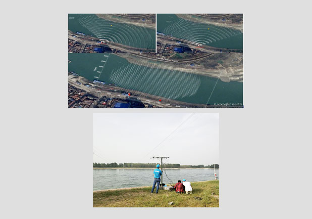
The most prominent advantage of RISMAR-U is that it can measure the river surface velocity and flow in real time in a non-contact way, and the installation site is not required. UHF radars need to be erected in river embankments mostly in wild mountains and mountains, which is not convenient for staff to live. In order to facilitate the use and management of UHF radar, RISMAR-U system uses computer network to realize remote monitoring and data transmission.
(5) Software functions:
_3. Supporting data to be imported into the reservoir according to the water condition, which conforms to the national standards and norms of hydrology and water regime in southern China, northern China and so on, and realizes the direct quotation and compilation of Hydrology Bureau data;
_5. The operating platform is WINDOWS series operating system.
_6. Data can be automatically calibrated according to the flow measurement
_7. According to the measured
_8. According to the flow calculation curve and the
9. Automatic generation of flood hydrological elements extract table;
_10. Support
_11. Test data storage can be divided into original information table and application result table. The two types of tables conform to the table structure and Identifier Standard SL323-2011 of the Ministry of Water Resources Real-time Rainfall Database.
12. The results of flow measurement can be filtered by the following means: sliding average of time intervals according to weighted time intervals of flow calculation elements
- prev:none;
- next:none;